Joining Forces to Deliver Next Generation Surveying Solutions
About Midland Surveying, Inc.
Owned and operated by Professional Land Surveyors, Midland Surveying, Inc. is a leading provider of land surveying services throughout the Midwest, and more recently throughout the Continental United States, for more than 44 years. At Midland Surveying, we believe leading by example is the only way to do business.

Midland’s experience in providing a multitude of ground-based survey services for large and small scale projects is unparalleled among small business survey service providers in the central United States. That experience includes projects for federal and state agencies, as well as for small commercial and residential developments. Midland Surveying, Inc. is a HUBZone certified small business concern, providing specialized land surveying and mapping services to numerous state and federal agencies, as well as other contractors seeking to meet HUBZone contracting goals. Midland Surveying provides professional services primarily under NAICS codes 541370 and 541360. The HUBZone program, for “historically underutilized business zones” has enabled Midland Surveying, Inc. to expand our base of services that we can provide to state and federal agencies. Overall, the program encourages business growth and employment opportunities for small businesses in underserved communities.
About SAM Companies
SAM is the nation’s largest combined geospatial solutions and construction services provider and the leader in our industry. We pioneer the deployment of innovative solutions for collecting and analyzing complex data across a wide range of markets and infrastructure projects. Our national reach, expertise, and applied technologies uniquely equip us to capture physical environments from coast to coast — delivering practical insights and high-quality georeferenced data with unrivaled speed and accuracy. We deliver fast, accurate data to give our clients the insight they need to move their projects forward with confidence.
SAM provides turnkey solutions through the combined support of our geospatial solutions and construction service teams. Our diverse services enhance one another, bringing fresh perspectives to potential challenges at every stage of your project. We offer a complete range of services such as surveying, mapping, and utility engineering to support construction of utilities, drainage improvements, and facilities including barracks and airfields, as well as boundary surveying for military bases, parkland, and national forests. SAM’s nationwide surveying and mapping services lay the foundation for fast, reliable planning, design, and construction for federal projects of all types and sizes.
SAM holds decades of experience supporting contracts for the U.S. Army Corps of Engineers, The U.S. Air Force, Department of Veterans Affairs, Department of Agriculture, and the Department of Interior and numerous federal agencies and bureaus. Our projects have resulted in “exceptional” performance evaluations due largely to our responsiveness and ability to tailor solutions to meet client needs.
About Our Partnership
Midland Surveying & Mapping JV is approved as a SBA Mentor-Protégé Program (SBAMPP) between Midland Surveying, Inc. (Protégé) and Surveying and Mapping, LLC (Mentor). The JV partnership combines the resources and capabilities of the two firms resulting in a HUBZone Joint Venture with coast to coast reach and licensed land surveyors across the U.S. Our services include all types of surveying:
- Cadastral and Boundary
- Topographic
- Control Survey
- Construction Layout
- 3-D Scanning
- Mobile LiDAR
- Airport Obstruction
- ALTA/NSPS
- BIM Modeling
- Subsurface Utility Engineering
- Utility Designation
- Aerial Mapping
- Orthoimagery
- LiDAR
- UAS and Fixed Wing Platforms
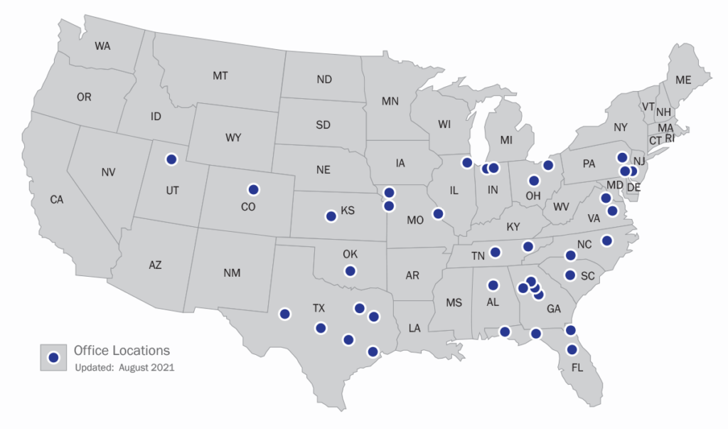
Partnership Combined Office Locations

Key Information
CAGE 94JU8
DUNS 118204519
541370 – Surveying & Mapping Services (primary)
About Our Team & Contacts

© 2021 Midland Surveying & Mapping JV. All Rights Reserved.